Europe is not a continent that typically invites comparison with other planets. Its reputation is built on the human and the historical — on the accumulated architecture of three thousand years of civilization, on the cathedrals and the piazzas and the wine and the art and the particular quality of urban life that the continent has refined over millennia to a standard that no other part of the world has yet surpassed. When people think of Europe, they think of Paris in the rain and Rome in the heat and the sound of church bells in a Tuscan valley and the smell of coffee in a Viennese café. They do not, typically, think of lunar landscapes and volcanic craters and frozen waterfalls and black sand beaches and geothermal vents steaming in the middle of ancient lava fields.
And yet.
Europe contains, within its relatively compact geography, a collection of landscapes and places so extreme in their beauty, so alien in their visual character, so completely outside the frame of anything that the continent’s urban and cultural traditions would lead you to expect, that arriving in them produces in the visitor a specific and profound disorientation — the feeling of having stepped not merely into a different country but into a different physical reality, where the organizing principles of the world you know have been temporarily suspended and replaced by something older, stranger, and in its own way more magnificent.
These are the places that feel like another planet. Not in the metaphorical sense in which people describe anywhere sufficiently different from home. In the more specific sense of landscapes and environments that share more with the visual vocabulary of science fiction and geological imagination than with anything typically described in European travel guides — the black volcanic deserts of the Canary Islands, the alien rock formations of the Turkish coast, the geothermal infernos of Iceland’s interior, the salt flats and pink lakes of the Mediterranean’s strangest islands, the cave cities carved from volcanic rock, the basalt columns rising from northern seas like the pillars of a sunken civilization.
This guide covers the places in Europe — and in the European sphere, which includes the Azores, the Canaries, and Iceland — that most completely produce this sensation of planetary displacement. Each one has been selected not for strangeness alone but for the combination of extraordinary visual character, genuine accessibility, and the specific quality of experience that comes from standing somewhere that makes you feel, briefly and productively, that you do not know where you are.
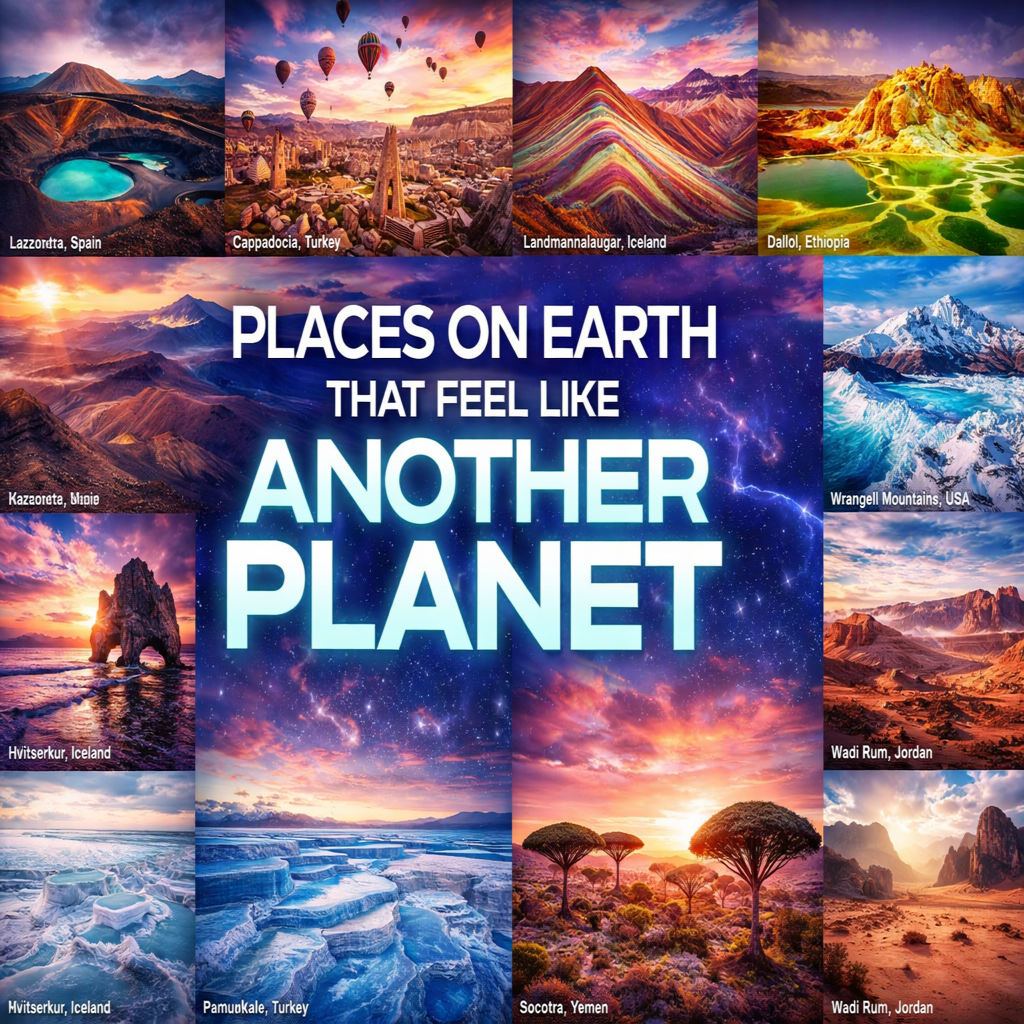
1. Lanzarote, Canary Islands, Spain — The Volcanic Planet
Lanzarote is the most otherworldly inhabited place in Europe and one of the most extraordinary volcanic landscapes on Earth. The island’s Timanfaya National Park — covering the southwestern third of the island in the lava fields produced by the volcanic eruptions of 1730–1736 (which lasted six years and covered a quarter of the island in lava) — is a landscape of such complete and total alieness that NASA has used it as a Mars analogue for astronaut training, and it is difficult, standing in the center of the Montañas del Fuego (Mountains of Fire) and looking in any direction at nothing but black and red and ochre lava fields stretching to the horizon, to dispute the comparison.
The Timanfaya volcanic landscape is accessible on foot (the Tremesana route guided walk, bookable at the national park) and by road — the Ruta de los Volcanes scenic drive winds through the most dramatic sections of the lava fields, passing cones and craters and solidified lava rivers whose surface textures range from smooth and ropy (pahoehoe lava, which cooled slowly) to sharp and jagged (aa lava, which cooled quickly and explosively) in a geological vocabulary that feels fundamentally unearthly.
The heat demonstration at the Islote de Hilario — the volcanic hotspot at the park’s center where park rangers pour water into a hole in the ground to produce an instant geyser of steam, and where chicken and meat are grilled in a wire basket lowered into a volcanic vent — communicates the geological reality of the island’s still-active interior with a dramatic directness that no geological explanation can match. The temperature 10 cm below the surface here is approximately 400°C.
Beyond Timanfaya, the Jameos del Agua and Cueva de los Jameos del Agua — a lava tube system running from the volcanic interior under the ocean, whose cave lake is home to a blind albino crab (Munidopsis polymorpha) that evolved in complete darkness and is found nowhere else in the world — is one of the most extraordinary cave environments in Europe. The Jameos del Agua was developed as an arts and culture venue by the Lanzaroteño artist and architect César Manrique, whose philosophy of integrating architecture with volcanic landscape produced a series of buildings and public spaces on the island (the Fundación César Manrique, the Jameos del Agua, the Mirador del Río) that are among the finest examples of vernacular modernism in Europe.
Getting there: Fly to Arrecife Airport (ACE) from major European hubs. The island is best explored by rental car.
Don’t miss: Timanfaya National Park on the Tremesana guided walk, the Ruta de los Volcanes drive, Jameos del Agua, the Fundación César Manrique in Tahíche (built inside and around five volcanic bubbles), the black sand beach of Playa de la Caletón Blanco, the salt flats of the Salinas de Janubio.
Best time to visit: Year-round — Lanzarote’s climate is consistently warm and dry. Spring and autumn avoid the peak summer crowds.
2. Cappadocia, Turkey — The Fairy Chimney Planet
Cappadocia is the most immediately disorienting landscape in the European geographical sphere — a region of central Anatolia whose volcanic tuff (compressed volcanic ash from eruptions millions of years ago) has been eroded by wind and water into the extraordinary formations known as peri bacaları (fairy chimneys): conical rock columns, some with harder basalt caps balanced on top, rising from the valley floors in clusters of hundreds that produce a landscape unlike anything else visible from the surface of this planet.
The Göreme valley — the UNESCO World Heritage core of the Cappadocia region, flanked by the settlements of Göreme, Uçhisar, Çavuşin, and Avanos — is the densest concentration of fairy chimneys and the finest base for exploring the wider region. The volcanic landscape here has been inhabited for thousands of years — the Hittites, then the Byzantines, carved their homes, churches, monasteries, and eventually entire underground cities directly into the soft tuff, producing the extraordinary troglodyte architecture that makes Cappadocia simultaneously a geological wonder and an archaeological one.
The Göreme Open-Air Museum — a Byzantine monastic complex of rock-cut churches decorated with some of the finest 10th and 11th-century Byzantine frescoes outside of Constantinople — is outstanding and one of the finest UNESCO World Heritage Sites in Turkey. The Dark Church (Karanlık Kilise) within the museum, whose frescoes are preserved in extraordinary freshness due to limited light exposure, is among the finest Byzantine painted interiors in existence.
The balloon flights — dozens of hot air balloons launching before dawn to float over the fairy chimney valleys in the first light — are Cappadocia’s most famous experience and entirely justify their reputation. Waking before sunrise, ascending above the valley in a basket with thirty other passengers, and watching the fairy chimney landscape below gradually illuminate in the early morning light as hundreds of other balloons drift alongside is one of the most visually extraordinary experiences in travel. Book well in advance and budget approximately €150–€250 per person for a reputable operator.
The Derinkuyu Underground City — accessible by bus or car from Göreme, 30 km south — is one of approximately 36 underground cities excavated in the Cappadocia region, descending 85 meters below the surface through eight levels of tunnels, rooms, stables, churches, wine presses, and ventilation shafts capable of housing up to 20,000 people. Standing in the deepest chamber, 85 meters below the fairy chimney landscape above, and understanding that this was built by human hands using iron tools in volcanic rock for protection against invasion, produces one of the most profound archaeological experiences in the world.
Getting there: Fly to Nevşehir Kapadokya Airport (NAV) or Kayseri Airport (ASR) from Istanbul (1 hour) or several European cities. Transfer by shuttle to Göreme. Best explored by rental car or local dolmuş minibuses.
Don’t miss: Dawn hot air balloon flight (book weeks ahead), Göreme Open-Air Museum, Derinkuyu Underground City, the Ihlara Valley gorge walk (15 km through a river canyon of extraordinary beauty), the Uçhisar castle rock (the highest point in the region), staying in a cave hotel (one of the finest accommodation experiences in Turkey).
Best time to visit: April to June and September to November. July and August are very hot. December to February is cold but magical for snow-dusted fairy chimneys and far fewer visitors.
3. Landmannalaugar, Iceland — The Rainbow Mountains Planet
Iceland as a whole belongs in any discussion of otherworldly European landscapes — the entire country is essentially a geological argument that the Earth’s surface is a temporary arrangement subject to revision without notice. But Landmannalaugar, in the central highland interior accessible only in summer and only by 4WD vehicles or the specially equipped highland buses, distils Iceland’s most alien qualities into a single landscape of maximum intensity: multicolored rhyolite mountains in shades of green, yellow, pink, purple, and red that bear no resemblance to any mountain landscape elsewhere on the continent, hot springs bubbling from the ground in rivers of steaming water, lava fields of obsidian black stretching between the colored hills, and an atmosphere of complete isolation from anything recognizable as contemporary civilization.
The rhyolite mountains — formed when magma cooled slowly beneath the surface, allowing the iron and other minerals in the rock to oxidize in the extraordinary range of colors that makes the landscape appear painted rather than geological — reach their maximum visual intensity at Landmannalaugar itself and along the first section of the famous Laugavegur Trail (the four-day hiking route from Landmannalaugar to Þórsmörk, widely considered the finest long-distance hike in Europe). The combination of the colored mountains above, the geothermal streams cutting through the lava fields below, and the natural hot spring pool at Landmannalaugar (where hikers soak in thermally heated water surrounded by the extraordinary landscape) creates an experience of such concentrated geological drama that the human nervous system requires several hours to adequately process it.
The Hekla volcano — visible on clear days from Landmannalaugar, one of Iceland’s most active and most feared volcanoes — adds a final layer of geological menace to the landscape. The entire region sits within Iceland’s volcanic zone, and the evidence of geological activity — the steam vents, the hot springs, the fresh lava flows from relatively recent eruptions — creates the specific awareness of standing on a living, tectonically active surface that is one of the most instructive and most humbling experiences that European travel can provide.
Getting there: Drive from Reykjavik (approximately 3.5–4 hours, 4WD vehicle essential as several river crossings are required) or take the Reykjavik Excursions highland bus (the F225 route from Reykjavik operates June to September). Accessible only from approximately late June to early September when highland roads are open.
Don’t miss: The natural hot spring at Landmannalaugar base camp, the first day of the Laugavegur Trail for the finest rhyolite mountain scenery, the obsidian lava field of Laugahraun, the view of Hekla on the horizon, night camping under the midnight sun in summer.
Best time to visit: Late June to August — the only time the highland roads are reliably open and accessible.
4. Dallol, Danakil Depression — Beyond Earth Entirely
Strictly speaking, the Danakil Depression is in Ethiopia rather than Europe, but for European travelers it merits inclusion as the most extreme landscape accessible from European airports on a short-haul trip and the destination most completely unlike any other on this list or, arguably, on Earth. The Dallol hydrothermal area — at 116 meters below sea level the lowest land point on Earth, in the hottest inhabited place on the planet (average annual temperature 34.4°C) — is a landscape of hydrothermal springs, salt formations, sulfur fields, acid pools, and mineral deposits in colors — acid yellow, neon green, white, orange, blood red — that appear digitally altered and are entirely natural.
The Danakil is accessible from the Ethiopian town of Mekelle on organized tours (typically 3–4 days), traversing a landscape that progresses from salt flats (where the Afar people harvest salt using traditional methods unchanged for centuries) to the Erta Ale volcano (a persistently active shield volcano with a permanent lava lake — one of only a handful in the world) to the Dallol hydrothermal field. The combination of the lava lake’s red glow in the night sky, the salt flat caravans, and the Dallol color fields constitutes a journey through a landscape so extreme and so various that every hour brings a visual environment entirely unlike the one preceding it.
This is not a comfortable or straightforward travel destination — the heat is genuinely extreme, the infrastructure is basic, and the remoteness requires careful preparation and a reputable local guide operator. It is also, for travelers willing to engage with these conditions, the most completely other-planetary experience available from any European airport.
Getting there: Fly from European hubs to Addis Ababa, connecting to Mekelle. All Danakil tours are organized from Mekelle with mandatory armed escort. Several European tour operators run organized Danakil expeditions.
Don’t miss: Erta Ale lava lake (ideally at night when the glow is most dramatic), Dallol hydrothermal field at sunrise, the Afar salt caravans on the Karum salt flat, the Asale salt lake, the Ahmed Ela salt mining village.
Best time to visit: November to March — the Danakil’s hottest months (May to September) produce temperatures that regularly exceed 50°C and make the journey genuinely dangerous.
5. Wrangell-St. Elias — Wait, Wrong List. Let’s Stay in Europe: The Azores, São Miguel — The Green Planet
The Azores archipelago — nine volcanic islands in the mid-Atlantic, an autonomous region of Portugal geographically closer to North America than to continental Europe — is the greenest and most improbably lush volcanic landscape on Earth. São Miguel, the largest island, concentrates the Azores’ most dramatic geological features into a single landscape of extraordinary variety: the twin calderas of Sete Cidades (one lake emerald green, one cornflower blue, their different colors the product of different light angles — or, according to the island’s most romantic legend, of the tears of a princess with green eyes and a shepherd with blue eyes forbidden to meet), the Furnas valley (a geothermal depression of steaming fumaroles, hot springs of volcanic mud, and a lake whose shore is heated by volcanic vents where the local cozido das Furnas stew is slow-cooked underground in geothermal heat), and the Caldeira Velha waterfall (a cascade of thermal water through tropical tree fern forest).
The Sete Cidades caldera — 12 km wide, formed by a volcanic collapse approximately 22,000 years ago, its crater floor divided between the two color-contrasted lakes and surrounded by steep caldera walls covered in a hydrangea-blue ocean of flowers in summer — is the finest single landscape in the Azores and one of the most beautiful in the North Atlantic. The view from the Vista do Rei belvedere on the caldera rim — the two lakes below, the caldera walls reflected in their surfaces, the Atlantic visible beyond the rim on clear days — is among the finest panoramic views in European travel.
The Furnas valley is a living demonstration of the island’s volcanic geology — the fumaroles (steam vents) hissing and bubbling around the edge of the Furnas Lake, the caldeiras (hot spring pools of boiling mud) generating an extraordinary smell of sulfur and earth, and the remarkable sight of local restaurant workers lifting the pots of cozido das Furnas stew from their underground geothermal cooking positions beside the lake, serving a dish that has been slow-cooked for six hours by the heat of the Earth itself.
Getting there: Fly to João Paulo II Airport, Ponta Delgada, São Miguel (PDL), from Lisbon (2.5 hours) and several European cities including London (2.5 hours). The island is best explored by rental car.
Don’t miss: Vista do Rei belvedere over Sete Cidades calderas (at dawn for the clearest views), the Furnas valley fumaroles and a cozido das Furnas lunch, Caldeira Velha waterfall, the Nordeste coast (the oldest and most geologically settled part of the island, with extraordinary coastal cliffs), whale watching from Pico island (ferry from São Miguel — blue and sperm whales are regularly sighted).
Best time to visit: May to October. The summer months bring the finest weather and the full blue of the hydrangeas in flower.
6. Hvítserkur, Iceland — The Stone Beast Planet
Iceland returns to the list, this time for a specific and singular formation on the Vatnsnes peninsula of northwestern Iceland — the Hvítserkur basalt stack, a 15-meter volcanic rock formation rising from the Húnaflói bay that has been worn by centuries of wave erosion into a shape so precisely resembling a drinking rhinoceros (or, from certain angles, a dragon or elephant) that the resemblance appears deliberately sculptural rather than geological. At low tide it sits on a rock shelf; at high tide it appears to float on the sea’s surface; at sunset with the tide rising around its base and the pink sky behind, it produces a quality of visual unreality that is one of Iceland’s most striking natural images.
The Vatnsnes peninsula more broadly — accessible from the Ring Road on a scenic 60 km loop — is one of Iceland’s finest and least visited coastal landscapes: seal colonies on the black sand beaches, the ancient turf farmsteads of the Hvammstangi area, and the mountain reflections in the still waters of the Miðfjörður bay providing a journey of concentrated natural beauty that takes half a day and rewards with complete solitude in a landscape of extraordinary quality.
The broader northwestern Iceland region — the Westfjords, the most remote and most dramatically beautiful of Iceland’s geographical regions, accessible by road from Hvítserkur or by ferry from Stykkishólmur — is the most completely otherworldly coastal landscape in Iceland: its flooded glacial valleys creating fjords of extraordinary depth and complexity, its waterfalls cascading directly onto the fjord shores, its cliffs holding the largest Atlantic puffin colony in the world at Látrabjarg (the westernmost point in Europe), and its roads so remote and so dramatically situated that driving them constitutes one of the finest road trip experiences in Europe.
Getting there: Drive from Reykjavik (approximately 3.5 hours to the Hvítserkur viewpoint) on the Ring Road and Vatnsnes peninsula loop. The Westfjords are a further 2–3 hours north.
Don’t miss: Hvítserkur at low tide and at sunset, the Vatnsnes seal beaches, the Westfjords if time allows (Ísafjörður as base, Látrabjarg puffin cliffs, Dynjandi waterfall — one of the most beautiful in Iceland), the Snæfellsnes peninsula on the return to Reykjavik (Snæfellsjökull glacier and the Jules Verne connection).
Best time to visit: June to August for accessibility and the midnight sun. October to March for Northern Lights (from the Vatnsnes peninsula, away from light pollution, the aurora displays can be extraordinary).
7. Pamukkale, Turkey — The Cotton Castle Planet
Pamukkale — the “Cotton Castle” in Turkish — is one of the most surreal natural formations in the world: a hillside in the Denizli province of southwestern Turkey covered in brilliant white terraced pools of calcium carbonate-rich thermal water, their pale blue mineral water cascading from one natural travertine terrace to the next in a formation so white and so geometrically regular that from a distance it appears to be covered in permanent snow, and from close up resembles the surface of some mineral-rich alien world.
The travertine terraces are formed by the calcium-rich thermal waters (temperature approximately 35°C) flowing from seventeen hot springs at the summit of the hill and depositing calcium carbonate as they cool on the slope below — a geological process ongoing for hundreds of thousands of years that has built up a hillside of white mineral deposits 160 meters high and 2,700 meters wide. The effect from the valley below — the white terraces against the vivid blue of the sky, the steam rising from the summit pools, the ancient ruins of Hierapolis (the Greco-Roman city built above the thermal springs) visible at the summit — is one of the most completely unexpected and most completely otherworldly images in European travel.
Hierapolis above the terraces — a UNESCO World Heritage Site combining the geological wonder of the travertines with the archaeological significance of one of the most important Greco-Roman cities in Asia Minor — adds a layer of historical complexity to the experience. The Hierapolis necropolis (the largest ancient cemetery in Anatolia, its tombs extending for 1.2 km along the ancient road), the Apollon Temple and its plutonium (a cave sacred to the god of prophecy whose toxic carbon dioxide emissions were used in ancient rites), and the extraordinary archaeological museum in the restored Roman bath complex are all outstanding.
Walking barefoot in the warm thermal pools of the travertine terraces — the officially permitted access method, which protects the white mineral surface from shoe damage while providing an experience of considerable physical pleasure — is one of the most genuinely unusual activities available in European travel.
Getting there: Fly to Denizli Çardak Airport from Istanbul or several European cities, or take the Pamukkale Express overnight train from Istanbul to Denizli (approximately 12 hours — an atmospheric and comfortable journey). From Denizli, frequent dolmuş minibuses serve Pamukkale village (20 minutes).
Don’t miss: Walking barefoot in the travertine pools at sunset (the light on the white mineral surface at this hour is extraordinary), the Hierapolis necropolis and archaeological museum, the Antique Pool (the Cleopatra Pool — a thermal swimming pool whose floor is covered with ancient Roman columns and architectural fragments, where you swim among 2,000-year-old marble in 36°C water — one of the most extraordinary swimming experiences in the world), the view from the summit terrace at dawn.
Best time to visit: April to June and September to October. Summer is very hot and crowded; winter is cold but the terraces are dramatically beautiful with fewer visitors.
8. The Giant’s Causeway, Northern Ireland — The Hexagonal Planet
The Giant’s Causeway — the extraordinary basalt column formation on the Antrim Coast of Northern Ireland, where approximately 40,000 interlocking hexagonal basalt columns descend from the clifftops to the sea in a geological formation so precisely geometric that every human civilization that has encountered it has attributed it to supernatural construction — is the most geometrically precise natural landscape in Europe and one of the most visually extraordinary coastal formations in the world.
The columns — formed approximately 60 million years ago when volcanic lava contracted as it cooled, cracking into the hexagonal pattern that minimizes internal stress (the same pattern found in honeycomb, in dried mud cracks, and in other materials that contract uniformly from a liquid or semi-liquid state) — range from 15 to 40 cm in diameter and up to 12 meters in height, descending from the clifftop level to the sea in a series of formations named for their shapes: the Giant’s Boot, the Wishing Chair, the Honeycomb, the Chimney Tops. The visual effect — hundreds of perfectly regular hexagonal columns packed together in a formation of alien precision, descending into and disappearing beneath the North Atlantic waves — is genuinely and profoundly strange.
The Irish legend of the Causeway — that it was built by the giant Fionn mac Cumhaill as a bridge to Scotland to fight his Scottish rival Benandonner, and that the corresponding basalt formation at Fingal’s Cave on the Scottish island of Staffa (accessible by ferry from Mull) represents the Scottish end of the same bridge — is more satisfying narratively than the geological explanation and equally plausible to anyone standing on the columns and looking at their extraordinary regularity.
The Antrim Coastal Road connecting the Giant’s Causeway with Ballycastle to the east and Bushmills (home of the world’s oldest licensed whiskey distillery, founded 1608) to the south provides the finest coastal drive in Northern Ireland and one of the finest in the British Isles.
Getting there: Drive from Belfast (approximately 1.5 hours) or from Derry/Londonderry (45 minutes). A National Trust car park at the Causeway site charges for parking; the Causeway itself is free to access on foot.
Don’t miss: The columns at low tide when they are fully exposed, the clifftop walk east to the Chimney Tops headland (the finest elevated view of the full Causeway formation), the Old Bushmills Distillery tour, the Carrick-a-Rede Rope Bridge (1 km east of the Causeway, a 20-meter rope bridge connecting the mainland to a small island above the sea — spectacular and vertigo-inducing in equal measure), the Cushendun Caves nearby (cave formations used as filming locations for Game of Thrones).
Best time to visit: May to September for the best weather. The Causeway in winter storm conditions — waves crashing over the lower columns, mist on the clifftops — has its own dramatic quality.
9. Saline di Trapani, Sicily — The Pink Salt Planet
The Saline di Trapani — the salt flats extending along the Sicilian coastline between Trapani and Marsala on the island’s western tip — are among the most unexpectedly beautiful industrial landscapes in Europe: a sequence of shallow evaporation pans divided by low earthen dykes, their water ranging from pale pink to deep magenta to brilliant white depending on the salinity and the specific algae and brine shrimp populations that colonize them at each stage of the evaporation process, the whole landscape punctuated by the silhouettes of ancient windmills whose sails have been turning in the Mediterranean wind to pump seawater through the salt production system for five centuries.
The pink color — caused by the halophilic (salt-loving) algae Dunaliella salina and the brine shrimp Artemia salina that colonize the most concentrated salt pans — intensifies from white through pale rose to deep crimson as the salt concentration increases, creating a palette of colors that bears no resemblance to any other coastal landscape in Europe and changes through the day as the light moves across the water’s surface. At sunset, when the low western light turns the pink water gold and the windmill silhouettes cast long shadows across the salt pans, the landscape achieves a quality of visual drama that is simultaneously entirely natural and completely theatrical.
The salt of the Saline di Trapani — sea salt harvested by traditional methods from these pans since the Phoenicians established the salt works here three thousand years ago — is considered among the finest and most mineral-rich in the world, its specific composition influenced by the mix of Atlantic and Mediterranean water that characterizes this stretch of the Sicilian coast. The Museo del Sale (Salt Museum) in the village of Nubia provides excellent context for the history and technology of the salt production.
The Egadi Islands — Favignana, Levanzo, and Marettimo, visible from the salt flat coastline and accessible by hydrofoil from Trapani in 20–50 minutes — provide the finest crystal-clear water snorkeling and the most unspoiled Mediterranean island landscapes in Sicily.
Getting there: Fly to Trapani Birgi Airport (TPS) or Palermo (1.5 hours by bus), or arrive by ferry from Cagliari or Naples. The salt flats are a 10-minute drive south of Trapani along the coastal road.
Don’t miss: The salt flats at sunset (the finest light of the day), the Saline Ettore e Infersa windmill and salt museum at Marsala, the view from the salt flat road of the Egadi Islands on the horizon, a Marsala wine tasting in Marsala town (the wine is named for and produced around this city), the Egadi Islands day trip from Trapani.
Best time to visit: June to September when salt production is at maximum and the colors are most intense. August provides the most dramatic pink coloration.
10. Socotra Island, Yemen — The Dragon Blood Tree Planet
Socotra Island, technically part of Yemen but geographically in the Arabian Sea equidistant between the Horn of Africa and the Arabian Peninsula, is the most biologically isolated and most visually alien inhabited island on Earth. Its 300 endemic plant species — found nowhere else in the world, evolved in complete isolation over millions of years — include the dragon blood tree (Dracaena cinnabari), whose perfectly umbrella-shaped canopy, flat-topped and surreally geometric, grows from a thick trunk of smooth grey bark and produces a deep red resin (the “dragon blood” of its name, used as medicine, dye, and ritual substance for thousands of years) in quantities that have made it one of the most harvested trees in the Arabian region.
A plateau covered in dragon blood trees — their identical flat umbrella canopies creating a forest of alien geometry, the red resin bleeding from any cut in their smooth bark, the overall visual effect more closely resembling a concept art rendering of an exoplanet than any landscape on Earth — is the definitive Socotra image, and it is entirely real.
The island’s other extraordinary endemic species — the bottle tree (Adenium obesum socotranum, whose swollen grey trunk stores water against the island’s dry season), the cucumber tree (Dendrosicyos socotranus, the world’s only tree-form cucumber, its absurd proportions suggesting the product of a biology experiment rather than natural selection), and the frankincense trees whose resin has been harvested for trade since antiquity — create a botanical landscape that no European country can replicate and few anywhere on Earth can approach.
Access to Socotra has been restricted by the Yemeni conflict since 2015, with periods of limited tourist access available through UAE-facilitated arrangements. The situation changes regularly — research current accessibility before planning and use only established, locally connected tour operators.
Getting there: Charter flights from Abu Dhabi (UAE) when accessible. Some operators run small group tours from Dubai.
Don’t miss: The Diksam plateau dragon blood tree forest, the Detwah Lagoon (one of the finest natural lagoons in the Arabian Sea), the Hoq Cave (an enormous limestone cave system with ancient inscriptions from sailors who sheltered here over millennia), the endemic bird species (Socotra has 10 endemic bird species including the Socotra sunbird and the Socotra sparrow), the white sand beaches of the northern coast.
Best time to visit: October to April when the monsoon season has ended and the island is accessible.
11. Wadi Rum, Jordan — The Red Desert Planet
Wadi Rum is technically in Jordan rather than Europe, but its accessibility from European airports (a 4-hour flight from most major European hubs to Aqaba) and its relevance to the otherworldly destination theme make it essential on any serious list. The “Valley of the Moon” — a protected desert wilderness of dramatic sandstone and granite inselbergs (isolated rock masses rising from a flat plain) rising from orange and red sand desert floors — is the landscape that Stanley Kubrick considered using for 2001: A Space Odyssey’s lunar sequences and that has since appeared in The Martian, Lawrence of Arabia, Dune, and Rogue One: A Star Wars Story. The comparison with Mars is not merely cinematic — the iron oxide in the rock and sand produces the extraordinary red-orange coloration that distinguishes Wadi Rum from every other desert on Earth.
The landscape combines vertical sandstone cliffs of 800 meters with natural rock arches, narrow siq canyons, ancient Nabataean petroglyphs, and the specific quality of desert silence and light that no photograph adequately communicates. The Bedouin communities who have inhabited and guided the desert for centuries provide the finest access to its most remote and most beautiful corners — sleeping in a desert camp under the stars, with the rock formations visible in silhouette and the Milky Way overhead in the absence of any light pollution, is one of the finest overnight experiences available in travel.
Getting there: Fly to Aqaba (AQJ) from Amman (30-minute domestic flight) or take the 4-hour bus from Amman. Most visitors combine Wadi Rum with Petra (2 hours north) for a Jordan circuit.
Don’t miss: A jeep tour of the major rock formations, a sunrise or sunset camel ride, an overnight in a traditional Bedouin desert camp, the Um Fruth rock bridge climb, the ancient Nabataean inscriptions at Khazali Canyon, stargazing from any point in the desert after midnight.
Best time to visit: March to May and September to November. Summer is very hot; winter nights are cold but the days are clear and beautiful.
12. Etna and the Sicilian Volcanic Landscape — The Active Planet
Mount Etna — the 3,357-meter active stratovolcano dominating northeastern Sicily, Europe’s highest active volcano and one of the most active on Earth — is the most viscerally geological landscape in Europe and the one that most directly communicates the planet’s ongoing geological activity to anyone willing to approach it. Etna erupts regularly (2020, 2021, 2022, and 2023 all produced significant eruptive events), its summit craters producing lava fountains and ash plumes visible from Catania and across the Sicilian coastline, and the evidence of its geological activity — the black lava fields of varying ages covering its flanks, the solidified lava rivers that crossed roads and vineyards in recent eruptions, the steaming fumaroles near the summit — makes it the most actively alien of all the volcanic landscapes in this guide.
The lower flanks of Etna — accessible by the Ferrovia Circumetnea narrow-gauge railway that circles the mountain’s base through towns built on and between ancient lava flows — produce some of the finest agricultural landscapes in Sicily: the volcanic soil growing extraordinary pistachios (the Bronte pistachio, grown in the volcanic soil at 700 meters altitude on Etna’s western flank, is the most intensely flavored pistachio in the world), the Etna DOC wines (the volcanic soil produces Nerello Mascalese reds and Carricante whites of extraordinary mineral character and growing international recognition), and cherries, figs, and almonds of exceptional quality.
The summit crater area, accessible on foot with a guide or by cable car and 4WD bus from the southern flank, provides the most completely alien landscape in Europe — black lava of various geological ages, steaming vents, and the awareness of standing on an active volcanic system whose next eruption is a matter of when rather than if.
Getting there: Fly to Catania Fontanarossa Airport (CTA) from major European hubs. Etna is 30 km from Catania, accessible by Ferrovia Circumetnea railway or by car.
Don’t miss: The cable car and 4WD ascent to the summit area (weather and volcanic activity permitting), the Valle del Bove (an enormous caldera on Etna’s eastern flank, one of the most dramatic geological formations on the mountain), the Bronte pistachio harvest festival (September/October), Etna wine tasting at a volcano-flank winery, the Ferrovia Circumetnea railway circuit (one of the finest narrow-gauge railway journeys in Italy).
Best time to visit: May to October for summit access. April and October for the finest light and smallest crowds. Winter provides dramatic summit snow against the black lava but summit access is often closed.
How to Plan an Otherworldly Trip
Combine geological and cultural destinations. Every destination in this guide is within a day’s travel of outstanding historical and cultural experiences that provide contrast and context. Lanzarote with mainland Spain, Cappadocia with Istanbul, the Azores with Lisbon, Sicily’s salt flats with the extraordinary archaeological sites of western Sicily (Selinunte, Segesta, the Valley of the Temples at Agrigento). The otherworldly landscape is most affecting when experienced against the backdrop of the familiar and the human.
Go early and go late. The alien quality of these landscapes is most intense at the extremes of the day — dawn and dusk, when the light is lowest, the colors most saturated, and the human presence most reduced. Pamukkale’s travertines at sunset, the Sete Cidades calderas at dawn, the Giant’s Causeway in the long low light of a Northern Irish summer evening — these are the conditions that produce the photographs and, more importantly, the experiences that justify the journeys.
Hire local guides for geological landscapes. The volcanic and geological landscapes in this guide all benefit from expert interpretation — the geology of Timanfaya explained by a park ranger, the fairy chimney formation history explained by a Cappadocia guide, the salt production process explained by a Saline di Trapani worker. The landscapes are extraordinary without explanation; they are transformed by understanding.
Respect the environments. Several destinations in this guide — Timanfaya, Pamukkale, the Giant’s Causeway — have suffered significant damage from visitor numbers and behavior. Follow marked paths, obey access restrictions, carry out all waste, and treat these geological formations with the respect due to things that took millions of years to create and can be destroyed in moments of carelessness.
Final Thoughts: The Earth Is Stranger Than We Remember
The places in this guide exist as a corrective to a specific kind of travel complacency — the assumption that the world has been fully catalogued, that the photographs we have seen tell the full story, that there is nothing left that will make us feel genuinely, productively disoriented by the strangeness and beauty of the planet we inhabit.
Standing in the middle of the Timanfaya lava fields with nothing but black and red volcanic rock in every direction. Looking down at the two-colored Sete Cidades lakes from the caldera rim. Walking barefoot through the warm mineral pools of the Pamukkale travertines. Watching a hot air balloon drift over a valley of fairy chimneys in the Cappadocia dawn. These are not experiences that fit comfortably into the usual categories of travel — they are not cultural, not gastronomic, not historical. They are geological and planetary and somehow fundamental — reminders that the Earth is a stranger and more extraordinary place than daily life, with its roads and buildings and schedules and screens, typically allows us to remember.
The most alien planet accessible from any European airport is the one you are already living on. You just need to go to the right part of it.
We hope this guide to the most otherworldly places in Europe has given you the inspiration and practical foundation to plan a journey of genuinely extraordinary character. For more hidden gem guides, extreme landscape destinations, and travel inspiration across the full breadth of the continent and beyond, keep exploring GlobeTrailGuide — your trusted companion for smarter, deeper travel.
GlobeTrailGuide.com | Travel Smarter. Explore Deeper.